|
|
London North Western
Railway:
Midland
Railway:
Stratford
Midland Junction Railway
|
|
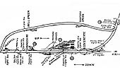
Longford & Exhall
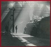
The station was built by the London and North Western
Railway and opened on 2nd September 1850 at the same time as the other stations
on the Coventry to Nuneaton Line (with the exception of Daimler Halt which only
serviced workmen from the adjacent Daimler factory). Longford & Exhall
station only handled passenger traffic, because with the absence of local
industries generating commercial traffic, both Bedworth and Foleshill stations
were near enough to cover any ad hoc need for goods traffic. The station was
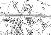
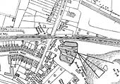
built on an embankment being accessed from the Nuneaton end of the station by a
footpath leading down from the up (Coventry) platform to Station Road, and from
the down (Nuneaton) platform, via steps to Woodshires Road. The bridge at the
Nuneaton end of the station forming the boundary between the two roads. The
platforms were lengthened, constructed by using timber, in the first decade of
the 20th century appearing in their lengthened form for the first time on the
1912 Ordnance Survey map. The station buildings, erected in 1850, were typical
low-cost structures being built using timber and to a design which pre-dates
the 'standardised' modular LNWR designs. The station was the first on the
branch to succumb to the competition of public transport being closed on 23rd
May 1949.
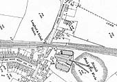
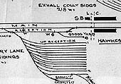
Reg Instone a member of both the LNWR and Signal Record
Societies writes, 'The signal cabin was brought into use in 1914, when some
new sidings were constructed, and had a frame for 35 levers. A down loop line
was added in 1916. I believe that for most of its life it was opened only for
two shifts on weekdays, the rest of the time the signalling instruments being
switched through between the boxes on either side (Bedlam Gate and Hawkesbury
Lane). For some time in the 1950s or early 1960s the signalman was Maurice
Croft, but he moved on to Griff Junction, near Nuneaton. It was the first box
on the Nuneaton branch to be abolished, being taken out of service over the
weekend of 9th to 10th June 1965'.
Ordnance Survey Maps and Control Strips
|