|
|
London North Western
Railway:
Midland
Railway:
Stratford
Midland Junction Railway
|
|
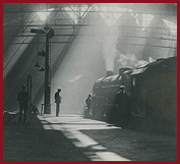
Granville Street Station
When the Birmingham West Suburban Railway was absorbed by the
Midland Railway with effect from 1st July 1875, the Directors quickly set about
completing the single line. On 5th October 1875 the Minutes of the Birmingham
West Suburban Construction Committee recorded that 'Mr Allport reported the
following ammendments would be necessary in connection with the opening of the
Birmingham West Suburban line for traffic.
Granville Street
Station
Platform to be made 300 feet long, cab stand for 6 cabs
to be made in the station yard, small wooden shed for branch line engine
provided near the station. The station requires signalling and interlocking. It
was also recommended that the line be doubled.
There is no evidence that the single shed was ever built.
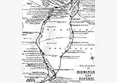
The Birmingham West Suburban Railway Act of 1871 originally
stated the terminus was to have been Albion Wharf. If this had been constructed
it would have provided a station close to the city centre on the opposite side
of Holliday Street from where the Worcester Wharf goods station was later
built. However, in order to save construction costs, the proposed line was cut
back and it terminated at a station alongside the Worcester and Birmingham
canal adjacent to a bridge under Granville Street. Andy Doherty of
Rail around
Birmingham writes, "The station was a modest affair consisting of a single
wooden platform, small wooden waiting room and ticket office with a passing
loop to enable a locomotive to run around the train for the return journey to
Kings Norton."
Andy continues, "Unfortunately for Granville Street station, it
became a victim of the line’s success some 9 years after opening.
Patronage of the line had been good from opening, the original Cadbury factory
at Bridge Street was a stone’s throw from the terminus and thus many of
its 230-strong workforce used the line, as did a significant number of the
population along its route. Whilst this, and the proposed Cadbury
factory’s move to a much larger site at Bournville also adjacent to the
BWSR, spelt prosperity for the line, the problem faced by the Midland was that
Granville Street was not ideally located near enough to the City Centre to
compete for a healthy slice of the growing rail-using populace. Furthermore,
the nearby Cadbury factory was closing thus patronage of the station would
reduce and there was no prospect of a link to the rest of the rail network from
the site: the station lay on ground being of significant height as to render
unviable an attempt to extend the line directly into New Street which lay at a
much lower level, from the station site itself.
In order to overcome these problems, the Midland set about
doubling the line from Kings Norton and undertook the engineering works
necessary to tunnel under the Worcester and Birmingham Canal at a level lower
than that at Granville Street, thus bypassing the terminus, to enter the hub of
the Midland/LNWR network at New Street station, in 1885. Thus, the death knell
had been wrung for Granville Street, which closed as the new section of line
opened. The station site itself was cleared in the ensuing months with the
Midland doubling its track from its junction with the New Street Extension of
the BWSR between the newly built Five Ways station and Church Road station and
driving a tunnel under the Worcester and Birmingham Canal to feed its new
Central Goods station at Suffolk Street, thus sweeping away all traces of the
short-lived station at Granville Street by 1887".
|