Miscellaneous: Operating Equipment & Practices
Miscellaneous Equipment: misc_equip195
GWR Map showing all engine routes colour coded
back to
top
Engine Map - Michael Clemens
Use the links below to access the following
images:
Section of GWR Route Map showing the lines within the
County of Warwickshire
back to
top
The Great Western Railway Engine Map shown here
is dated September 1931, although some routes on the map appear to have had
their route colours updated subsequently. This particular Engine Map was given
to Mr Clements by the Foreman at Worcester Shed.
The Great Western Railway classified their
locomotives by:
1) Route Colour –
This indicated the lines that each locomotives was allowed to travel
over
2) Power Group – This indicated
the maximum load the locomotive was capable of hauling
Extracts from an article written by H R
Griffiths for the Institute of Transport in July 1924 explaining how the
classification system worked has been transcribed below for information. Note -
There is no reference in this article to the double (or hatched) red lines seen
on the Engine Map, because the article was written before the 60xx (King) class
locomotives were introduced in 1927.
Table showing colour coding of routes for each type of
locomotive
back to
top
On the Great Western Railway an Engine Map is
used to indicate which of four different classes of engines may work on the
respective sections of line; the sections of line are marked red, dotted red,
blue, dotted blue, yellow and uncoloured and this map is the guide chiefly to
the locomotive staff to provide for line limitations fixed by the permanent way
engineer and based on the heaviest axle weights of various engines in relation
to the construction of the various lines and bridges, viz.,
- red lines over 17 tons 12 cwt
- blue lines 16 tons to 17 tons 12 cwt
- yellow lines 14 tons to 16 tons
- uncoloured under 14 tons
The red and blue line engines can work on the
dotted red and dotted blue lines at reduced speed. There are also certain other
engineering limitations in connection with clearances, e.g. where engines with
outside cylinders are used. The first table indicates generally the
significance of this engine map.
Table showing grouping for each type of locomotive
back to
top
For more general working purposes, engines are
grouped in six sections, described under letters A, B, C, D, E and ungrouped,
for calculating maximum loads according to the engine used. Particulars of this
grouping of Great Western engines are given in the second table and this allows
the maximum loads for each group of engines and three traffic classes with a
fourth for empties to be set out. In the table the diameter of the driving
wheel is given chiefly to enable the locomotive foremen to select those with
the longest diameter for the fastest timed trains. The engines classified as
ungrouped are the lighter ones used for shunting and local work and not on
truck trains.
The Engine Power Group information can be
summarised as follows:
| Power Group |
Tractive Effort at 85% |
| Ungrouped |
Under 16,500 lbs |
| A |
16,500 to 18,500 lbs |
| B |
18,500 to 20,500 lbs |
| C |
20,500 to 25,000 lbs |
| D |
25,000 to 33,000 lbs |
| E |
33,000 to 38,000 lbs |
| Special |
Over 38,000 lbs |
back to
top
Extract from a Service Time Table showing; traffic type
classification, ready reckoner and classification of special wagons
For the purpose of acertaining maximum loads up to the
engine capacity, the classification of traffics and wagons with over 10 tons
capacity are shewn in tables – a ready reckoner being given to calculate
equivalents of the various classes; for instance, 20 trucks of coal are
equalled by 24 trucks of ashes, 30 trucks of general goods, or 40 empty trucks.
A table with code descriptions (chiefly for telegraphic purposes) indicates the
equivalents of specially constructed wagons which would have a carrying range
up to 120 tons equal to 10 wagons of Class 1 traffic.
back to
top
Nomograph showing capability of locomotives of various
power groups on inclines
Nomographs such as this were used to calculate the maximum
number of wagons that could be hauled by locomotives of each power groups up
various gradients. This particular nomograph relates to the number of standard
10 ton wagons containing Class1 traffic.
back to
top
Extract from a Service Time Table showing Maximum loads
for different classes of traffic over various routes
Drivers were not expected to use the gradient nomographs,
but the results of this gradient calculation for each individual route section
was published in their local area Service Time Table (STT). This showed the
maximum number wagons of each traffic class that could be hauled by engines of
different power classes over individual sections of the route.
back to
top
Extract from a Service Time Table showing holding
capacities of refuge sidings and running loops
Although the maximum loading information might indicate that
it was possible for a particular locomotive to haul a large number of wagons
through an individual route section, it may be necessary for this freight train
to give way to a faster passenger service. This would be achieved by reversing
the freight train back into a refuge siding or diverting it into a running loop
to clear the main line. The length of each freight train therefore also needed
to be limited to the maximum holding capacity of the refuge sidings and running
lines along the route being traversed. A list was provided In the Service Time
Table for each area.
back to
top
Photographs showing route discs with letter
designations
Ref:
misc_equip196
Photo showing Yellow route disc with 'C'
designation
|
 |

Ref:
misc_equip196
Photo showing Red route disc with 'D'
designation |
|
Ref:
misc_equip196
Photo showing Blue route disc with 'C'
designation |
Ref:
misc_equip196
Photo showing Double Red route
disc
|
|
Ref:
misc_equip196
Photo showing Blue route disc with 'E'
designation |
back to top
The information about route availability and
locomotive capability was not just limited to the documentation. These
photographs show how each locomotive carried a coloured Route Colour disc
painted near the cab, on which a black Power Group letter was superimposed.
This simple visual system allowed the operating staff to compare; the
locomotive’s route colour with the colour of the lines on the Engine Map,
and look up the maximum loading over the route to be traversed by a locomotive
with that power letter.
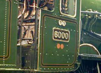
On the Engine Map the hatched Red routes are
those which can be traversed by the 60xx (King) class locomotives (with their
maximum axle weight of 22 tons 10 cwt), these locomotives had two red discs
painted on the side of their cabs.
back to
top
Wagon Labels
Two unused wagon labels, pre-stamped for frequent journeys.
Notice that the Traffic Class was prominently shown:
Number 'three' on the wagon label for perishable goods from St
Erth in western Cornwall to Moor Street goods depot for delivery to Birmingham
market.
'Empty' for the returning
Non-Common User Wagon
These wagon labels were attached to each wagon so
that the traffic class information was visible without the need for close
inspection. This allowed the guard to rapidly pass along the train and reckon
the total load. The guard could then compare this against the locomotive's
capability.
Robert Ferris
back to top
 back back
|