|
|
Stations, Junctions, etc
Engine Sheds
Other
|
|
London North Western
Railway:
Midland
Railway:
Stratford
Midland Junction Railway
|
|
Ettington Limestone Company
Goldicote Cutting
Very little information exists on the Ettington Limestone
Company. What we can deduce is that the quarry was an opportunistic enterprise
taking advantage of the railway's Goldicote cutting and the railway's desperate
need to generate revenue. John Jennings, archivist of the SMJ Association,
states the Ettington Limestone Company traded between 1905 and 1916 generating
'useful revenues' for the East & West Junction Railway'. The quarry
and limestone works were situated on the north side of the East & West
Junction Railway's single line track approximately three-quarters of a mile
from Ettington station. From the photographs seen below we can ascertain that
the quarry was designed to be accessed from the eastern end of Goldicote
Cutting. At this point, as can be seen in image 'smjel100', the ground immediately adjacent to the
railway is ten to twelve feet above rail level which meant once the overburden
was removed the narrow gauge line used to transport the limestone was of a
height sufficient for the narrow gauge wagons to be tipped into the standard
gauge wagons positioned alongside.
The quarry was formed by the simple process of the cutting
being widened to one side of the E&WJR line. Because the strata of
limestone followed the natural contour of the surrounding area it rose up
towards the track bed within the cutting. The further into the cutting the
deeper the cutting and therefore the limestone became more accessible without
the need to dig deep holes. Because this method of excavating the quarry meant
there was no physical barrier between the two enterprises, the E&WJR was
compelled to produce boundary markers (see image 'smjel220'). These were required to clearly mark the
boundaries between the two companies. Such demarkation was important not just
because of the need to ascertain which company was responsible for the
maintenance of its section of the line and siding, but because each enterprise
was subject to different parliamentary legislation which was overseen by
different government departments with different rules, regulations,
responsibilities and possible penalties. The available evidence strongly
suggests the quarry was not a large enterprise being limited to only a fairly
short section of land on one side of the cutting.
It has been suggested the quarry was much larger, extending
into the surrounding fields and subsequently backfilled to the original
agricultural profile. This is extremely unlikely for a number of reasons not
least because the cost of such an operation would have significantly outweighed
the value of the land reclaimed. In addition, the volume of material needed
would have been enormous and unlikely to have been available locally. When
comparing the configuration of the two stone quarry buildings seen one behind
the other in image 'smjel99', with that seen in image
'smjel192' it is quite apparent that the two
buildings were parallel with the railway. As the photographs were taken very
early on in the enterprise it can be seen the material behind the two buildings
had yet to be quarried. Examination of the 1921 Ordnance
Survey map (published 1924) which records the quarry after closure, shows
the final size of the quarry is indeed not very large nor did it encroach into
the fields to any great extent. This is also supported by examining the
satellite image taken in 2014 which shows
the location of the stone buildings in relation to the quarry at closure. The
excavation is now overgrown, as is the cutting, and is clearly not a massive
undertaking.
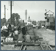
The facilities at the quarry comprised an exchange dock at
the eastern end of the cutting, where the stone was transferred between the
narrow gauge track to the E&WJR, and sidings. This consisted of a single
siding running more or less parallel with the E&WJR's line as it proceeded
towards Clifford Chambers, whilst in the opposite direction and at 90° to
the E&WJR's line were two short sidings, both fitted with buffer stops, and
located in a field behind a gated entrance. Image 'smjel100' shows the exchange sidings and 'smjel189' the siding running parallel to the E&WJR
line. The crushing plant was located approximately half way along the cutting
as it exists today. Goldicote cutting was some sixty feet deep and presumably
it was when it was being originally excavated that the limestone was first
exposed although it was decades later before any effort to extract it was to
occur. The benefit of the quarry to the E&WJR would appear in all reality
to be marginal but such was the state of the railway's finances, anything was
obviously considered to be better than nothing. In essence the extraction of
the limestone was only economic because it was effectively subsidised by the
railway company. Mike Christensen in his booklet Signalling of the SMJ
states that the siding was closed after the SMJ withdrew the
preferential rate which the quarry owners had previously enjoyed.
Clearly it couldn't stand on its own two feet otherwise. John Jennings notes
'the LMS had removed the connection by 1928 in their general tidy up of the
line in the late 1920s'. It's interesting to note that on all photographs
there is no evidence of branding, either as the Ettington Limestone Company or
as the Goldicote Quarry.
The quarry was worked throughout its working life by horse
rather than by steam traction, not only because the quarry was small and its
output very low, but as the photographs show, the narrow gauge track around the
buildings was too lightweight to have carried the weight of even the smallest
0-4-0 locomotive. A reference in Arthur Jordan's book on the SMJ supports this
view as he describes that 'in 1910 a horse wandering on the line through an
open gate caused the derailment of a cattle truck' the damage costing
£70. The use of a horse would also provide the necessary motive power for
both narrow and standard gauge traffic. The siding running adjacent to the
E&WR's single line appears to be laid with light weight short section flat
bottom rail which are fixed by spikes to unballasted timber sleepers. The two
short sidings behind the gated entrance would appear to be at a higher level
than the siding running adjacent to the E&WJR's single line. It would
therefore be possible for empty standard gauge wagons to be stored on the two
short sidings (wheels suitably chocked) and when required, released to run
under gravity into the exchange landing dock to be loaded. John Jennings also
notes that 'there were special arrangements for collecting loaded trains
from the sidings so as to eliminate the risk of run away unbraked trucks down
the nearby Godicote cutting'.
Goldicote Cutting
The most serious disaster requiring the services of the
Stratford upon Avon breakdown gang look place in 1915 when at 1:20pm on Friday
24th September, a farm bridge spanning the sixty-foot deep Goldicote Cutting
collapsed and completely blocked the line until 8:00 am on the following
Monday. In the meantime, passengers were conveyed by road between Stratford
upon Avon and Ettington stations. The original fifty-year old brick bridge, one
of two structures spanning the cutting, the other a bridge carrying a public
road, had been weakened by the passage of heavy steam traction engines to and
from the farm, the owners of which had repeatedly rejected the SMJ's suggestion
that an alternative nearby stronger bridge be used. At a meeting of the SMJ
directors in December 1914 the Engineer had reported fully on the dangerous
condition of the bridge and that 'Platelayers have been instructed for the
past five years to watch all bridges'. Typically, the SMJ accepted the
lowest tender both for a new girder bridge and for its foundations, a decision
which brought a train of trouble. After much accrimony involving the railway,
the contractors, the farmers and the Board of Trade, work began on the erection
of the new bridge, the steelwork for which the contractors unbelievably laid
out across the old weak bridge! On 20th September the SMJ engineer visited the
site and, finding the steelwork laid out on the old bridge, he ordered its
instant removal. As soon as his back was turned the contractors began
assembling the second girder on the old bridge with the disasterous result
already described. All available platelayers and other staff, including office
workers, were sent to clear the line with work continuing both day and night.
In the breakdown van Arthur Jordan's mother and an assistant maintained a
never-ending supply of tea and sandwiches for the men. A new girder budge was
erected and ready for use by February 1916 and this bridge can still be viewed
from the A422 road between Stratford upon Avon and Ettington.
Much of the information provided on this and other linked
pages has been derived from books written by: Arthur Jordan The Stratford
upon Avon and Midland Junction Railway published by OPC; JM Dunn's The
Stratford upon Avon & Midland Junction Railway published by The Oakwood
Press; RC Riley and Bill Simpson in their book A History of the
Stratford-Upon-Avon and Midland Junction Railway published by Lamplight
Publications; David Blasgrove in his book 'Warwickshire's Lost Railways'
published by Stenlake Publishing which has a brief illustrated overview of some
of the stations; and finally Geoffrey Kingscott's Lost Railways of
Warwickshire published by Countryside Books which has a section dedicated
to the SMJR with 'Now and Then' photographs. We would like to express our
thanks to the members of the SMJ Society (www.smj.me) for use of their
information and images, in particular the late John Jennings whose contribution
can be seen on many of our SMJ pages.
Goldicote Cutting
|